Are there any plans to help gps - with any trees it is absolutely horrible. I’ve rotated the rover antenna, the data center has a clear view but the yarbo STRUGGLES! There has got to be a way that it can handle minor lapses in gps better. Yarbo doesn’t travel that fast so it shouldn’t need full signal constantly to actually work.
They are working on improvements to their sensor fusion and more vision supported course corrections.
Yarbo needs at least 4 L2 satellites with a CNR of 37+ to be able to have cm level accuracy. It has to see the same L2 satellites as the DC for it to be able to use them. If it doesn’t see the same 4+ satellites, then it goes into RTK status 5 which is float mode. This is dm level accuracy and it will continue for about 30 seconds in those mode. It loses accuracy over time and distance traveled in float mode. Then it will pause and wait for enough common satellites to be stable enough to regain precision and then start back up. The hope is that this time and accuracy can be improved over future software updates.
Depending on your density, you can try speeding up the work plan speed to see if you can recover signal fast enough for it to not go into float mode or to get out of float and back to RTK status 4 quicker. This can be counterproductive if the areas have NGZ’s and other obstacles and it stays in float long enough to lose accuracy and potentially veer off path into these zones. So, I would recommend monitoring these areas and your diagnostics screen to see that you do not have these issues.
Yea +1, this has me feeling less than thrilled about my very expensive purchase.
Yarbo murdered a baby maple and went for some forsythias today. The rover thought it was where it wasn’t. A few minutes later it drove between two rocks and nearly into the road. Glad I was there babysitting. I shouldn’t have to be there babysitting, so, @ianwalter, I hear ya.
At least for me this is the exception and not the rule. But when it goes wrong after running into a poor GPS signal location under some tree canopy, it’s obvious that it can really go wrong.
Yea it doesnt make sense because I’ll move it like a foot and it regains “green” gps signal and continues so it seems like floating mode isn’t working at all and its not polling for signal properly. Mammotion RTK didn’t have this problem. I’ve never seen a “yellow/orange” gps signal, its always been none or green which is bizarre.
The place I have my charger set up is very intermittent on GPS for some reason. One day it’ll have good signal, but most of the time I have to drive my mower out a couple of feet to regain GPS, and then send it to mow, instead of it just going out to mow on a schedule.
I am just getting started with yarbo but in the setup process also really struggling with loss of gps and yarbo function under tree cover. i also am very surprised thus far at how little grace period there is between loss of gps and loss of function - this may make yarbo virtually unusable on my property, as there are so many tree covered areas interspersed among the open areas. advanced vision technology seems to exist in other robot mowers, minimizing or alleviating gps dependence. it would be AMAZING if yarbo’s robust design could pair with an ability to navigate under tree cover for extended or unlimited periods. as of this moment, i am unsure if my yarbo will stay or return. i am still hopeful, but also finding myself stymied in mapping efforts by our current heavy cloud cover which seems to be making the gps problem significantly worse to the point of giving up for the day. how in the world can it function to remove snow - is it unable to snow blow while snowing, ie does it have to wait to clear the snow until snowing stops and sun comes out??? also, i would second the phenomenon described where the signal strength flips between poor and excellent (red and green) and never anything in between. agree, this seems bizarre - in searching for location for data center, all searched locations, including ones i am confident should have 120 degree view of sky, kept flipping between poor and excellent - in the end, i have no idea of the suitability of the locations - so do i have to use trial and error walking in slow motion behind yarbo over 4 acres of mowed lawn to see which location yields the best result???
Let’s see if we can find a problem and maybe solve it. Can you provide a screenshot of your DC diagnostics (can access from the diagnostics screen)? Please show the install location of your data center and if you can show a screenshot of your diagnostic page at your dock (include RTK, status, data center, and halow sections) and also include a screenshot of it under a problem area. You can blur out the GNGGA sections (GPS coordinates).
Well there’s that…
Yeah just post one picture at a time. You can’t put multiple yet until you’ve leveled up some.
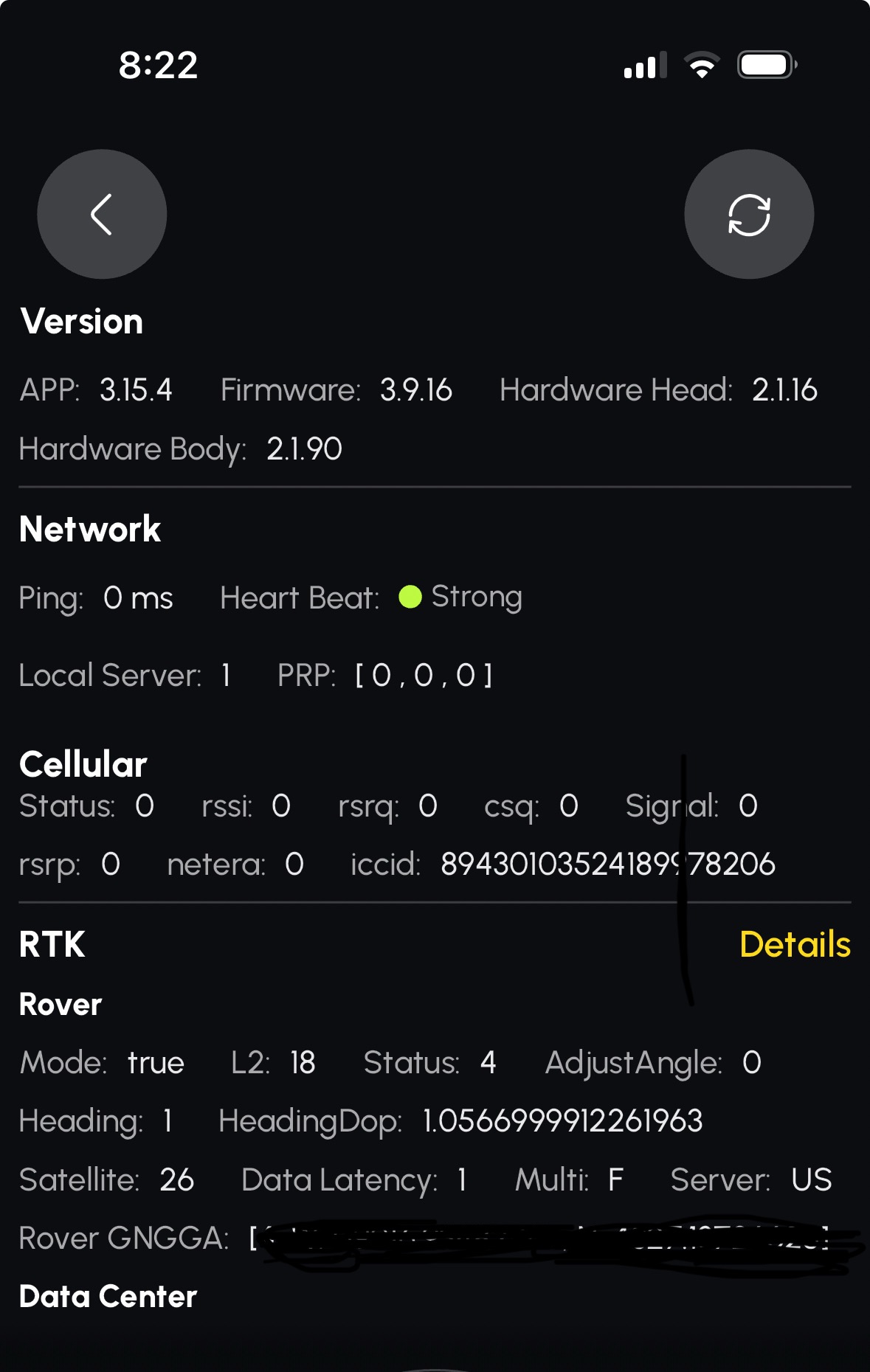
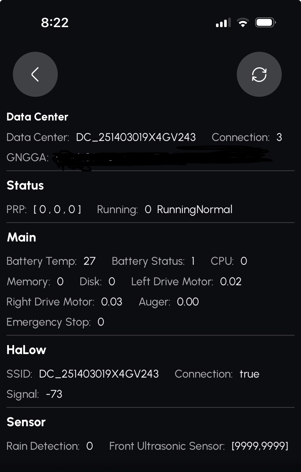

Those all look good. Where is that screenshot from, on the docking station or out in the problem area? What does it look like when you tap details there under RTK on the right? This will be the DC’s view of the satellites. Can you snap a photo of your DC install location as well?
- HaLow signal kinda on the edge. Could this be switching networks?
- Update Status showing – what is that? Mine doesn’t show the 100% or “Ready” or that yellow bar. Reboot needed to finish something?
That’s why I asked where it was. But it’s still within range.
The update status is normal if you tap that. Always says 100% unless it’s actively updating.
@Ken if you hit the update button that’s what it shows when it’s updated. At least that what I believe
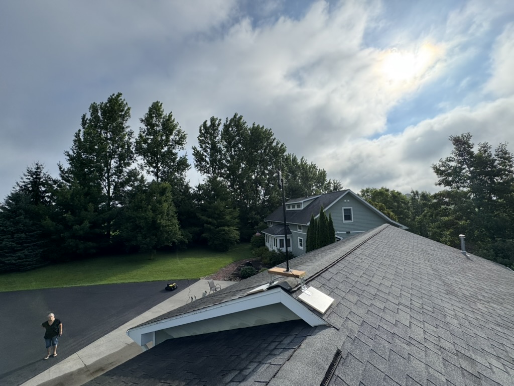
I’ve spent the day troubleshooting. I was never able to get sufficient signal to be able to finish installing the data center at the location those screenshots were taken from (garage roof), stayed “poor” the whole time I was trying, at least 30 minutes, so I ended up moving it up on top of my house which is higher than the garage by at least 10 to 15 feet but closer to a line of trees that are extremely tall (probably 100 feet high). the signal waffled between poor and excellent, so I grabbed it during an excellent and temporarily installed it there so I could trial some more mapping with the patrol function (I don’t have the lawnmower pro yet until it ships in august or whatever). It worked a little better GPS-wise, but still a LOT of dead spots on the property. simultaneously, the patrol mapping seems to have a lot of software glitches so between the two problems I am admittedly pretty frustrated. Not ready to give up by a long shot though, I am determined. Hopefully I will get more flexibility with this chat function to facilitate some troubleshooting. I think I will need to take one locale/one gps deadspot at a time to learn from you how to troubleshoot so I can figure out how to troubleshoot on my own for the property. I also am hearing that software updates for navigation under trees are coming soon??? here is pic from the garage roof location (that wasn’t working yesterday or this morning):